I said that I will explain many things about Earth and its processes from the position of modern science. I know that it is long but this is for enthusiast and curious people. So this is written on very simplistic way.
Also I presume that people know the most basic things in geography.
This post will probably give a deeper meaning to my statements that I don’t see the world as majority does.
If some one wants to discus the Science vs religion
This is the thread to do it.
Darwin would be ashamed
People are free to quote parts here and place them there. I will reply there.
I will start with the basic stuff.
Today on Earth there are 3 major Oceans and 7 continents that are making the borders between oceans.
Which is true but that is simplistic way of looking at the things.
When people come at the beach looking at the ocean they think that they have come at the edge of a continent.
The thing is that continents are stretching themselves hundreds of miles into the seas that covers the edges of continents. The only reason why "the beaches of the world" are where they are is because of current sea level. In the last 10 000 years this level is stabile. But this timetable is very short time on geological time scales.
There are two factors that change the sea level.
1. The amount for water trapped in ice (of all kinds) rivers and lakes
2. The rate(s) of sea floor creation. Which are less known to public.
Why creation of sea floor?
Because Earths crust is divided in to fragments which are also known as plates.
However they don't correspond to physical objects on the surface.
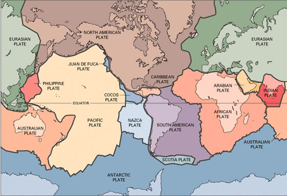
Here is the picture of distribution if the plates. But in this picture the author has ignored many small pates. In reality things are much more complex.
Here is a picture of N.America in Cretaceous period when the sea level was much higher because of plate tectonics.
The thing is that those plates are moving all the time.
There are 3 ways of how they move.
1.They are trying to drift apart.
2.They moving towards each other. (And create quite a show)
3.They just drift next to each other.
1.Case
The thing is that Earth must always be completely covered with crust. So when the plates are drifting apart it comes to melting of the Earths mantle so magma comes out and forms a new crust to fill in the hole. But the process never stops. The thing is that so much magma comes out in this process that it forms entire mountain chains at the bottom of the ocean.
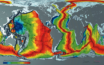
Here is how this looks like. this picture shows major ocean ridges of the world.
But because of the oceans/water you can’t see this mountain chains even if the chain is about 40 000 miles long. They were discovered by accident since the USA and USSR were looking for other sides submarines in the oceans.
But on that picture you can see one more thing. If you watch carefully you will see that continents are elevated. On this picture this is vastly over expressed so that it is visible to a viewer. The places where you have those "cliffs" there are the actual edges of the continents.
2. Case
The two plates are crushing “head to head”
This case is very devastating. This type of contact can create some interesting scenarios. Since the can be 3 sub-types of collision.
Ocean crust – Ocean crust
Ocean crust – continental crust
Continental crust – continental crust
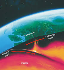
This picture shows how new crust is being created and the mid ocean ridge and it goes beneath a continent where it melts.
Here is how that looks from more practical perspective.
This is why North-western part of the US is so active when it comes to volcanos.
The thing is that there are always the differences in crusts density.
But continental crust is always less dense then ocean crust. So when those two fragments hit each other the denser one starts to slip under the less dense.
As more and more time goes by the more and more crust slips under, creating one of those deep trenches where the depth of the ocean is quite large.
But as the crust that continues to slips under it comes to great depths and it starts to melt.
So the outcome of this process is hot magma. Which then find its ways to the surface by melting rocks on its way. In the end it comes out to the surface through a volcano. This is why we have so many volcanoes on the coasts of Pacific Ocean. The islands that made Japan, Philippines and many other islands were formed this way. If you take at map of the world you will see that next to all those islands there are deep trenches. This are the trenches that are byproducts of oceanic crust sliping under another fragment. There are more examples.
Islands of Sumatra and Java in Indonesia are good examples, where you have the same situation. Even the tsunami that happened in 2004 was a direct byproduct of those processes.
This process is strong and active one. Earth is 4.5 billion years old but the oldest ocean crust is only about 200 million years old which is because the older crust is destroyed in the process. It is destroyed since it was pushed under the continents where it was melted.
On the picture the red is newer crust created on ridges and blue is the oldest crust.
3. Case
Is nothing really special. Two plates are just moving next to each other.
This is the case and San Andreas fault line where North American plate is moving next to Pacific plate. From time to time they can get stuck and to get unstuck they need Earthquake.
The plates are going all around the place and carry the continents with them.
But it can happen that two continents collide to each other because of this.
When that happens there is no slip under process for the most part. Instead you have a creation of high mountain chains in which there is no strong volcanic activity.
The entire Himalayan chain is a direct byproduct of India-Asia collision and there is no expressed volcanic activity there.
This is what you get in this case, a hight mountains and very thick continental crust.
As continents collide they don’t stay together forever since plates can carry the continents in separated ways.
For example North America and Europe collided some 430 million years ago and stayed like this for about 200 million years.
But this collision is what created Appalachi mountains. Same works for parts of Scotland, Norwegian mountain chain and mountains on Greenland.
But the continent that was created this way was on the equator since plates are moving.
This was with two continents but it can happen that many continents that come together and create a huge continental mass. This was the case with Pangea super continent that existed in a period for 300 to about 230 million years ago.
Back then all continents were gathered together in one huge mass.
Many people tried to create a puzzle made of continents but they have failed.
What is actually logical because of many reasons .
First they did not match the real sizes. Since the actual edges of the continents are far form coast. I have already mentioned this.
Another thing is that continents get upgrades with time. Plus the get rotated and compressed.
At this moment it looks like that there is continent cycle of about 0.5 billion years. What means that continents gather every 500 millions of years of so.
So what is actually a continent?
The Earth is the planet with two types of crust.
First one is made of rock called basalt and it forms bottoms of the oceans.
The second one is made of Granite and it makes continental crusts.
The continents are big in size but they are very thin compare to their size. The average thickness of continents is a couple of dozens of kilometers on average.
In the beginning there was one huge ocean of lava that covered the entire surface of Earth. So the first solid crust was similar to modern oceanic crust. However some parts become dense enough to sink back to the molten ocean. With enough time this processes created the difference in density of solid pieces. So overtime the parts that are thicker and more acidic in chemistry become the cores of future continents and the thin parts that were less acidic become oceanic crust.
This is very simplistic but this is the basic concept of continent formation.
However there is one more source of volcanism besides tectonic plates.
It is a hot spot volcanism. This volcanism is the byproduct the fact that at some places we have a melting of the Earths mantle. So you get large amount of magma at one place, what is called Hot spot. The most famous hot spot in the world are Hawaii islands. Since in this places lava does not have to make its own way through continental crust it does not get contaminated. What means that it is much more fluid then it would be that this is not the case.
That is the reason why volcanism on Hawaii is so calm and un-explosive.
This spots are scattered across the globe but majority of them is in tropical and sub-tropical areas. What is because Earth is spinning.
So centrifugal forces are forcing magma to come out in those parts of the world. In the most cases of course.
But if you ever look carefully on a detailed map you will see that Hawaii stretch as islands quite long in a direction towards the Japan. That is because hotspot is stationary but the Pacific plate is on the move. So the hot spot creates volcanos over and over again but the plate carries them far far away. .
In the case that hot spot comes under a continent it can happen that it will be too weak to penetrate the continental crust.
Those are the most basic stuff. Now I will go to one more complex story.
Some 270 million years ago all continent were merged into one huge continental landmass. But at that time the super continent started to crack on two parts.
The northern was made of future N. America, Europe and Asia while the Southern was made of S, America, Africa, India, Australia and Antarctic.
What separated them was something known as Tethys ocean. Which started as continuation of Paleo-Tethys ocean.
So here how that actually looked like in one moment.
The ocean stretched itself from eastern US all the way to Australia.
What made transformation was something know as Chimmerian blocks. Which have detached from southern continents and slam into the northern continents. Today this blocks are parts of Turkey, Iran and, Himalayas. But on the northern coasts of Africa in the Tethys ocean there was a strong sedimentation. What means that a lot of sea organisms lived there and they left their skeletons there when they have died. However this parts because of global plate tectonic drift apart from Africa. And they were drifting towards Europe which was to the north. Those large pieces of material have come to the open sea conditions which means in the centre of Tethys ocean.
There they created something known as carbon platform. Modern Bahamas are one very good example of this in the modern world.
But what happens then ? It happens that this platform starts to close in on Europe and it collides with Europe. Which is because the entire Tethys ocean is shrinking.
What means that Africa and Europe are coming closer to each other.
But Africa was pushing hard enough for this entire carbon platform(s) to fold and come out from the sea. That is why Europe has those high mountains made of limestone on its south. When you look at pictures from Italy, Croatia and Greece you will see a lot of gray around. Al those gray limestone rocks are nothing more then something that once looked like Bahamas and it was pushed strong enough to come out from the sea. Even today in those rocks you can find the remains of sea organisms.
Here is how the remains of those organisms look like.
I could say more but I don’t want to make too long post.
This was just to give people a general idea about main processes.


")